Tag Archives: Pacific Northwest National Scenic Trail

USFS releases Pacific Northwest Trail management plan

Good article . . .

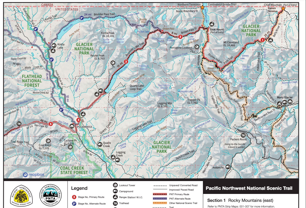
From the Chief Mountain port of entry on the Montana-Canada border, a dedicated hiker can follow a series of backcountry trails, bike paths, old rail beds, paved roads, bushwhacks, and cow paths, all the way to the beach of Cape Alava, Wash., the westernmost point in the continental United States.

This stitched-together route connecting Glacier National Park and Olympic National Park, known as the Pacific Northwest Trail (PNT), stretches 1,200 miles, “from the Rockies to the sea,” crossing seven National Forests, six wilderness areas, and three national parks, as well as tribal, municipal, and private lands in Montana, Idaho and Washington.

In December, the U.S. Forest Service released the final version of the PNT comprehensive plan, a document which outlines a vision for the non-motorized trail and provides guideposts for management, conservation and use into the future. The trail has only existed in its official capacity for 15 years, and like other early national scenic trails “much more work is needed to complete the optimal route from end to end,” the plan states.

Continue reading . . .

Forest Service releases plan for Pacific Northwest Trail

T26-T3-PNT Intersection Sign, July 11, 2020 - W. K. Walker

T26-T3-PNT Intersection Sign, July 11, 2020 – W. K. Walker

This was a long time coming . . .

The U.S. Forest Service has released a comprehensive plan for the Pacific Northwest National Scenic Trail, marking a milestone for a route established in 2009 but used by hikers for decades prior. The Forest Service, through the U.S. Department of Agriculture, released the document mid-December, outlining a vision for the trail and providing management, protection and use guidance.

“It’s been quite an effort to get to this point,” said Jeff Kish, executive director of the Pacific Northwest Trail Association.

The trail has existed in some capacity and seen use by hikers since the 1970s, Kish said. It was officially designated by Congress as part of the National Trails System in 2009, providing opportunities for hiking and backpacking across the Northwest United States, including through Lincoln County. The comprehensive plan is the latest step in a years-long process and fulfills requirements mandated by federal legislation.

Continue reading . . .

Forest Service taking public comment on Pacific Northwest Trail plan

T26-T3-PNT Intersection Sign, July 11, 2020 - W. K. Walker

T26-T3-PNT Intersection Sign, July 11, 2020 – W. K. Walker

The Pacific Northwest National Scenic Trail (PNT) runs through the North Fork from the Polebridge area westbound along trails 3 and 26 to Mt. Locke where it drops off the Whitefish Divide into the Kootenai National Forest . . .

The U.S. Forest Service is seeking public input regarding a management plan for a 1,200-mile hiking trail that stretches from the Continental Divide to the Pacific Ocean.

The Pacific Northwest National Scenic Trail starts in Glacier National Park, passes through Northern Idaho and then ends in Olympic National Park in Washington.

While the trail has existed since the 1970s, Congress only approved legislation for the Pacific Northwest National Scenic Trail in 2009, adding it to the National Trails System. Other designated trails include the Pacific Crest Trail and the Appalachian Trail.

Continue reading . . .